Geotag v.6.0.170.4
Advertisement
Description
Geotag is an open source program that allows you match date/time information from photos with location information from a GPS unit or from a map.The algorithms in Geotag automatically match GPS data to your photos. For photos taken when your GPS didn't have a signal you can let Geotag make a guess based on the closest available GPS information.
- Rate:
- Release Date:05/26/2011
- License:Freeware
- Category:Personal and Home
- Developer:Andreas Schneider, Geotag
- Downloads:17
- Price: Free
To free download a trial version of Geotag, click here
To visit developer homepage of Geotag, click here
Advertisement
System Requirements
Geotag requires Windows.
Geotag v.6.0.170.4 Copyright
Shareware Junction periodically updates pricing and software information of Geotag v.6.0.170.4 full version from the publisher using pad file and submit from users. Software piracy is theft, Using crack, password, serial numbers, registration codes, key generators, cd key, hacks is illegal and prevent future development of Geotag v.6.0.170.4 Edition. Download links are directly from our publisher sites. Links Geotag v.6.0.170.4 from Bittorrent, mediafire.com, uploadfiles.com, hotfiles.com rapidshare.com, megaupload.com, netload.in, storage.to, depositfiles.com and other files hosting are not allowed. The download file is obtained directly from the publisher, not from any Peer to Peer file sharing applications such as Shareaza, Limewire, Kazaa, Imesh, eDonkey, eMule, Ares, BearShare, Overnet, Morpheus, BitTorrent Azureus and WinMX.
Review This Software
More Geotag Software
Advertisement
Geotag Security v.1.0.0.1
When posting a photo on your favorite Social Network, online photo gallery, or web page, you are inviting danger.Most smartphones and some cameras made today are equipped with geo tags.

Geotag photos v.4.0.0.0
Maps with gps location direction speed in kilometres per metres per second miles per hour and a facility to tag photos with your location. v4.0 - Added 7 Day free trial
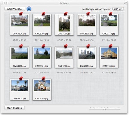
Latipics for Mac v.2.0
If youOCOre already using the Google Latitude service on your mobile phone or you want to start using it, Latipics will allow you to geotag your pictures based on where you were at the time the picture was taken!
Locr GPS Photo v.1. 2. 2004
With our locr PC software 'locr GPS Photo for Windows' you can manage to automatically geotag numerous photos simultaneously. You just require a digital camera, a GPS data logger and the application 'locr GPS Photo for Windows'.
Acute Photo EXIF Viewer v.1.0
View photo and image metadata (EXIF, IPTC/NAA, etc.). Supports many photo and image formats including most raw formats. Features include drag and drop, printing and ability to show GPS location (geotag) from Google Maps. Portable application.
RoboGEO
Geocode photos (including RAW) from a GPS. Stamp the images or write (lossless) to the EXIF headers. Create web pages using Google Maps, export KML/KMZ files to Google Earth, upload to Flickr, export shapefiles (SHP) or AutoCAD DXF files. Supports Garmin
ITag v.334.0
This software can add to any audio or movie file title, description, keywords and rating. Supports JPEG, TIFF, RAW, WMV and AVI file types. You can also search for files that do not have tags in order to add them.
PixGPS v.1. 1. 2005
With PixGPS it's easy to track the exact positioin where you took your photos. You need a GPS Receiver. All you need to do is to have the GPS turned on when you ake the photos.
PhotoMapper v.6 1
PhotoMapper will assist in organizing your memories by adding a geographic position to the EXIF-data that is already present in your files, so called geotagging.
Cloudatag Media TagCloud v.1.0.0
Cloudatag means Cloud Data Tag. Cloudatag manages your photos and videos with Tag Cloud which is a visual depiction of tags. So, you can instantly find or filter out the specific photo on the Cloud or your computer. Cloudatag provides a better way
ExIf DSC v.20100326
ExIf viewer for digital cameras. An software similar to ExIf 35, except for Digital Still Camera users. Application will provide tagging, rotation and ExIf viewing support. Photographers can also add copyright and contact informations.